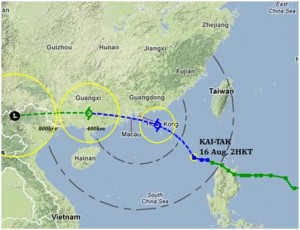
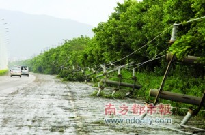
Weather warnings have been hoisted across the PRD as strengthening winds and heavy rains from Tropical Cyclone Vicente approach the coast of Guangdong.
In Hong Kong and Macau, the No. 3 typhoon signal was hoisted, and in the mainland, blue and yellow warnings were in force. The Hong Kong Observatory is warning that a typhoon No. 8 signal - which means no work for our compatriots south of the boundary - will be issued at 6pm or before today.
Vicente is expected to move further in a northwesterly track later on today, passing over the western coast of Guangdong Province.
The Hong Kong Observatory says the cyclone will pass within 200km of Hong Kong tonight and tomorrow morning.
Tropical Storm Doksuri was the first No. 8 typhoon storm of the year, while severe Tropical Storm Talim ushered in the tropical cyclone season for 2012.
However, the wild weather is not just confined to the Delta. In Beijing, the worst floods in 60 years claimed the lives of 37 people and displacing 65,000 people according to the BBC.
Update: 17:30pm
Around Guangdong, storm warnings have been adjusted. In Hong Kong, the Observatory hoisted a No. 8 Northeast typhoon signal at 5.40pm. The Macau Meteorological and Geophysical Bureau hoisted its respective No. 8 signal at 7pm.
Update: 22:45pm
As Tropical Cyclone Vicente edges closer to the west of the Delta, by 10pm tonight, it is only 130km southwest off the coast. The storm has intensified over the past few hours, and overnight, signals may be upgraded once more if strong winds persist and increase as it reaches the west of the Delta. In Hong Kong, the Observatory recorded winds of 125 kilometres per hour at Ngong Ping on Lantau Island. AlertNet, a Thompson Reuters service, is estimating Vicente will make landfall at 7am local time on Tuesday morning.
Update: 23:45pm
The Hong Kong Observatory has upgraded Tropical Storm Vicente’s strength from a storm signal No. 8 to a No. 9, as it hovers south of the Delta, making it a severe typhoon.
Also, meteorologists from AccuWeather.com reckon this storm is equivalent to a Category 1 hurricane. They say parts of Guangdong can expect between 10-20 inches of rainfall which raises concerns of severe flooding and mudslides.
Update: Tuesday: 00:45am
The Hong Kong Observatory has added a thunderstorm warning alongside storm signal No. 9 for Vicente, now a severe typhoon. Now only 110km off the coast of Hong Kong, at Ngong Ping, Lantau Island, wind speeds have reached 156 kilometres per hour. Low-lying areas may be hit by flooding due to high waters.
Update: 01:05am
Within the past 20 minutes, the Hong Kong Observatory has hoisted a hurricane signal No. 10. While Macau’s signal remains the same, it has issued a yellow storm surge warning - which is the first of three staggered warnings monitoring water levels inside the inner-harbour area.
Update: 01:30am
The Hong Kong Observatory has added a landslip warning alongside the hurricane signal No. 10 and thunderstorm warning.
Update: 02:15am
More warnings from the Hong Kong Observatory. An amber rainstorm warning has been issued, meaning as much as 30mm of rain an hour could fall, alongside a special warning for flooding in the northern New Territories. In Ngong Ping, wind speeds have now reached 180 kilometres per hour.
Vicente is the first hurricane signal No. 10 to be issued since 1999. According to statistics on the Observatory’s website, since 1946, only 13 typhoons have succeeded in claiming a No. 10 signal - or as the Observatory puts it: a “direct hit” on Hong Kong. Thanks to Melvin Pang for the tip.
Update: 02:30am
And in Macau, a tropical cyclone warning No. 9 has been issued along with a red storm surge warning. Neighbouring Zhuhai has hoisted a red cyclone warning and other cities in the west including Jiangmen and Zhongshan have upgraded their yellow to orange rainstorm warning.
Update: 03:00am
The online website for French news channel France 24 is running with an AFP report stating 34 people have been injured by the extreme weather.
As far as weather warning updates go, Guangzhou adds a yellow rainstorm warning. Meanwhile, Hong Kong’s Observatory says Vicente will make landfall in the coastal area of Taishan.
Update: 03:45am
The Washington Post says wind speeds reached the equivalent of a Category 4 hurricane. It talks about the rarity of No. 10 signals, which The Nanfang touched on. The story adds what Reuters has put out on a financial note: if Vicente’s No. 10 signal is still in force by morning, Hong Kong’s stock exchange will not open until stormy conditions have subsided. Normally disruptions of such a scale only occur in No. 8 or higher storms.
But we may have spoken too soon. The Observatory in Hong Kong has hoisted a No. 8 southeast signal. In Macau, they may replace their signal with a No. 8 signal in the next several hours.
Update: 07:30am
Since the last update, Vicente made landfall in Taishan, just west of Zhuhai and Macau, as predicted. The tropical cyclone still has a lot of strength, weakening a fraction as it travels inland. It’s predicted to travel further west, skirting the western coast of Guangdong, entering Guangxi Province and making its way into northern Vietnam. Throughout its journey, Vicente will dump a lot of rain in these areas, making flooding a possibility.
Weather warnings have been adjusted over the past few hours. In Hong Kong, it remains a No. 8 storm with warnings for amber rainstorm, landslips and acute flooding over the New Territories. Macau also hoisted a No. 8, lowering from a No. 9, and at 6.30am, cancelled all storm surge warnings. In the mainland, warnings are mostly unchanged from overnight, apart from certain areas such as Guangzhou and Zhaoqing increasing warnings as the storm pushes further inland.
Update: 14:00pm
As Vicente crosses into Guangxi Province, it is gradually losing strength - now with the power of a severe tropical storm.
The Hong Kong Observatory downgraded Vicente to a No. 3 strong wind signal, with a warning for landslides. Macau have a tropical storm No. 3 warning out. In Shenzhen, all warnings have been lifted. The west of the warnings in the Delta still remain in the far west. Zhaoqing still has an orange tropical cyclone warning. Throughout the rest of the day, strong, gusty winds will persist, as will the wet weather.
Update: 15:00pm
Dongguan has followed Shenzhen in cancelling all warnings. Other mainland warnings for tropical storm and rainstorms remain in force.
And the Observatory in Hong Kong has downgraded its warning to a No. 1 standby signal, and its landslip warning has been cancelled, too.
Update: 23:00pm
Vicente is passing over Nanning, Guangxi Province, as a tropical storm. Cities in the west of the PRD still have weather warnings out tonight. Foshan, Jiangmen, Zhaoqing and Zhongshan have orange rainstorm warnings while Zhuhai has a yellow signal in force. Hong Kong has a No. 1 standby signal in place but the Observatory will replace this signal with a Strong Monsoon signal later tonight. Everywhere else in the Delta, no warnings are in place for tonight.
Update: 23:30pm
Post-Vicente, Hong Kong’s Observatory has put a Strong Monsoon signal up. All other cities mentioned in the 23:00pm update, warnings remain unchanged.

 0
0


